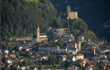
Zams - Kronburg - Patscheid
Hiking & mountain tour
Leisure and Recreational Hiking
From Zams, the trail leads via Anreit and Rifenal to the Kronburg pilgrimage church. The short ascent to the Kronburg ruins (approx. 25 minutes) offers a marvellous view of the surrounding mountains. The way back leads over the Zammer Patscheid.
Medium
11,10 km
380 m
03:45 h
Medium
Route
11,10 km
380 m
03:45 h
1068 m
Starting Point
Venetbahn Valley Station
End Point
Venetbahn Valley Station
Description
From the Venetbahn valley station, the trail leads along the former railway line to Zammer Oberdorf, from where you follow the Way of St James to the pilgrimage site of Kronburg. Once there, a path leads up to the Kronburg ruins, which offer a marvellous view of the surrounding mountains and to Zams and Landeck. A stop at the Kronburg inn makes up for the strenuous climb. The way back leads across the Zammer Patscheid meadows to Zams hospital and along the former railway line back to the starting point.
Best Season
Jan
Feb
Mar
Apr
May
Jun
Jul
Aug
Sep
Oct
Nov
Dec
Elevation Profile & Characteristics
Skill Level
Endurance
Amenities & Features
Circular hike
Path Conditions
Forest path, asphalt, gravel
Public Transport
From the Landeck-Zams train station, take Line 1 to the Venetbahn stop. Check the SCHEDULE.